Hancock County Maine
- Profile
- Images
Date:
15 Sep 1759
Location: Hancock County, Maine, United States
Surnames/tags: Maine Hancock_County_Maine
Location: Hancock County, Maine, United States
Surnames/tags: Maine Hancock_County_Maine
This page has been accessed 1,664 times.
| ... ... ... is a part of Maine history. Join: Maine Project Discuss: Maine |

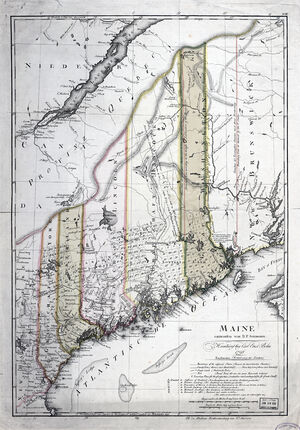
Hancock Countylies along the coast of Maine and is bordered on the west by Waldo County, along the north by Penobscot County, and Washington County to the East. The county was incorporated on June 25, 1789 and named for John Hancock, the first governor of the Commonwealth of Massachusetts. The land was formerly part of Lincoln County. In 1816 a portion was taken to form Penobscot County, in 1827 another section became part of Maine Waldo County . Neighboring Washington County was formed at the same time as Hancock County.
Contents |
Land Grants and other acquisitions
Townships, Land Grants and other acquisitions
Towns
| Town/City | Date | Parent Town | Parent County | Note/Name Change |
|---|---|---|---|---|
| Amherst | February 2, 1831 | Mariaville | Hancock | |
| Aurora | February 1, 1831 | Hampton | Hancock | Hamton prior to Feb 6 1833 |
| Bar Harbor | February 23, 1796 | Mount Desert Plantation | Hancock | Eden prior to March 5, 1918 |
| Bingham's Penobscot Purchase | January 1, 1791 | unorganized territory | Hancock | |
| Blue Hill | January 12, 1789 | Township No. 5 EPR Newport Plantation | Lincoln | |
| Brooklin | July 23, 1849 | Sedgwick, Port Watson | Hancock | Port Waston prior to July 23, 1849 |
| Brooksville | June 6, 1817 | Sedgwick, Castine & Penobscot | Hancock | |
| Bucksport | June 27, 1792 | Buckstown Plantation | Hancock | Buckstown prior to June 12, 1817 |
| Buckstown Plantation | June 27, 1792 | Township No.1 EPR | Hancock | Bucksport after June 12, 1817 |
| Castine | February 10, 1796 | Penobscot | Lincoln | |
| Cranberry Isles | March 16, 1830 | Mount Desert | Hancock | |
| Dedham | February 1,1837 | Township No. 5 EPR | Hancock | |
| Deer Isle | January 30, 1789 | Deer Island Plantation Organized 1762 | Hancock | |
| Eastbrook | February 8, 1837 | T15 MD BPP | Hancock | |
| Eden | February 23 1796 | Mount Desert | Lincoln | Bar Harbor after March 5, 1918 |
| Ellsworth | February 26, 1800 | Township No. 7 EPR | Hancock | |
| Franklin | January 24,1825 | T8 SD & T9 SD | Hancock | |
| Frenchboro | February 11, 1857 | Long Island Plantation, Islandport | Hancock | |
| Great Pond | March 5, 1895 | T33 MD | Hancock | |
| Gouldsboro | February 16, 1789 | Township #3 EUR Gouldsboro Plantation | Lincoln | |
| Hampton | February 1, 1831 | Plantation Number 27 | Hancock | Aurora. after February 6, 1833 |
| Hancock | February 21, 1828 | Sullivan, Trenton, T8 SD | Hancock | |
| Lamoine | February 11, 1870 | Trenton | Hancock | |
| Mariaville Plantation | January 1, 1822 | T26 MD | Hancock | |
| Mariaville | February 29, 1836 | Mariaville Plantation | Hancock | |
| Mansell | June 3, 1848 | Mount Desert | Hancock | Tremont after August 8 1848 |
| Mount Desert | February 17, 1789 | Township #3 EUR Mount Desert Plantation Organized 1776 | Lincoln | Town of Mount Desert Island (and Nearby Islands) |
| Orland | February 12, 1800 | Township No. 2 EPR | Hancock | |
| Osborn | February 11, 1976 | T21 MD | Hancock | |
| Otis | March 19, 1835 | Township No. EPR | Hancock | |
| Penobscot | February 23, 1787 | Township No. 3 East of Penobscot River, Livermore Survey | Lincoln | previous names include, T3 EPR LS; Township No. 3 West of Union River; Majorbigwaduce (Magorbigwaduce, Magabagwaduce, Maja Bagadoose, etc.) |
| Port Watson | June 9, 1849 | Sedgwick | Hancock | Brooklin after July 23, 1849 |
| Sedgwick | January 12, 1789 | Township No. 4 EPR | Lincoln | Incorporated1789 from Naskeag Plantation |
| Sorrento | March 3, 1895 | Sullivan | Hancock | |
| Southwest Harbor | February 21, 1905 | Tremont | Hancock | |
| Stonington | February 18, 1897 | Deer Isle | Hancock | |
| Sullivan | February 16, 1789 | Township #2 EUR | Lincoln | Previous Designations Waukeag; New Bristol |
| Surry | June 21, 1803 | Township #6 EPR | Hancock | |
| Swans Island | March 26, 1897 | Swan's Island Plantation | Hancock | |
| Swans Island Plantation | January 1, 1795 | Swan Purchase of Burntcoat Island | Lincoln | purchased 25 Feb 1785, first permanent settler in 1791. |
| Tremont | June 3, 1848 | Mount Desert | Hancock | Mansel prior to August 8 1848 |
| Trenton | February 16, 1789 | Township #1 EUR | Lincoln | |
| Verona | February 18, 1861 | Part of the Waldo Patent (Muscongus Patent); Nalagwemmenahen; Ahlurmehsic; Island of Lett; Penobscot Island; Buckstown Island; Orphan Island; Wetmore Isle Plantation | Part of Waldo's Patent (Lincoln Co.) then Hancock Co. 1789 | Verona Island after March 27, 2004 |
| Waltham | January 29, 1833 | T14 MD | Hancock | |
| Winter Harbor | February 21, 1895 | Gouldsboro | Hancock |
Maps
|
|
| ||||||
|
|


Villages, Locations and Settlements
- Hancock County currently has one city (Ellsworth), 36 towns, and 4 townships, including Marshall Island.
- Several towns were once part of Hancock County, but are now part of other counties, Isleboro (1789 to 1827), Northaven, and Vinalahaven (1789 to 1838) come to mind as well as other towns in Penobscot (1816) and Waldo (1827) Counties.
- Townships, Towns & Cities in UPPER CASE
- Villages, Locations and Settlements lower case and link to parent town
- List is incomplete!
Timeline
- 17,000 years ago, the last glacial period ended. Habitation of present date Maine prior to that is unknown. The glacier is responsible for many of the geologic features that make Maine unique.
- 5,000 years ago. The first known habitation by the people called "Red Paint people"
- 1600 CE an estimated 32,000 Wabinaki people inhabited the area that is now Maine and New Brunswick
- 1613 A French priest, Father Pierre Biard, who lived among the Wabanakis from 1611-1613, described how Micmacs and Maliseets appeared to him and how they got their living. The French were the first Europeans to explore the area. 1613 St. Sauveur Mission: In the summer of 1613, a violent collision of European empires took place in the vicinity of Mount Desert Island in Maine. Within a few weeks of its founding, the French Jesuit mission of Saint Sauveur was destroyed by a force of Englishmen commanded by Samuel Argall, who sailed from Virginia’s Jamestown settlement aboard the ship Treasurer. Several Frenchmen were killed, others driven away in a small boat, and the rest taken captive to Jamestown. Among those killed was Gilbert du Thet, the first Jesuit missionary to die in North America. Saint Sauveur Mission
- September 15, 1759 Wolfe's victory on the Plains of Abraham ended the conflict between France and England over Acadia and Eastern Maine
- 1762 Land Grants
- Township #1 EPR (Bucksport);
- Township #1 EPR (Orland);
- Township #1 EPR (Penobscot);
- Township #1 EPR(Sedgwick);
- Township #5 EPR (Bluehill);
- Township #5 EPR (Surry).
- Township #7 EPR (Ellsworth)
- Township #8 EPR (Dedham)
- Township #1 EUR (Trenton), granted to Eben Thorndike et als;
- Township #2 EUR (Sullivan), to David Bean et als,
- Township #3 EUR (Mt. Desert & Gouldsboro) to Gov. Bernard.
- Township #4 EUR (Steuben)
- Township #5 EUR (Harrington )
- Township #6 EUR (Addison)
- February 10, 1763 The Treaty of Paris of 1763 [1] ended the French and Indian War/Seven Years’ War between Great Britain and France, as well as their respective allies. In the terms of the treaty, France gave up all its territories in mainland North America, effectively ending any foreign military threat to the British colonies there.
- July 4, 1776 , the Second Continental Congress unanimously adopted the Declaration of Independence, announcing the colonies’ separation from Great Britain
- September 3, 1783 The Treaty of Paris, signed officially ending the American Revolutionary War.
- 1783 district of Maine became a political part of the Commonwealth of Massachusetts
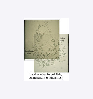
- October 28, 1783 unappropriated lands in the County of Lincoln, sold to James Swan
- February 23, 1787 Penobscot
- January 12, 1789 Sedgwick & Blue Hill
- January 30, 1789 Deer Isle
- February 16, 1789 Gouldsboro & Sullivan & Trenton
- February 17, 1789 Mount Desert
- June 25, 1789 Hancock County is formed from parts of Lincoln County
- June 27, 1792 Bucksport
- February 10, 1796 Castine
- February 23, 1796 Eden renamed Bar Harbor March 5, 1918
- February 12, 1800 Orland
- February 26, 1800 Ellsworth
- June 21, 1803 Surry
- March 15, 1820 Maine became the nation's 23rd state
- January 24,1825 Franklin
- March 16, 1830 Cranberry Isles
- June 13, 1817 Brooksville
- July 3, 1827 Waldo County is formed - from portions of Lincoln and Hancock County
- February 21, 1828 Hancock
- February 1, 1831 Aurora
- Feb 5, 1831 Amherst
- January 29, 1833 Waltham
- March 19, 1835 Otis
- February 29, 1836 Mariaville
- February 1,1837 Dedham
- February 8, 1837 Eastbrook
- June 3, 1848 Mansell - renamed Tremont 2 months later
- June 9, 1849, Fort Watson incorporated - renamed Brooklin a month later
- February 11, 1857 Frenchboro
- February 18, 1861 Verona
- February 11, 1870 Lamoine
- March 3, 1895 Sorrento
- March 5, 1895 Great Pond
- February 21, 1895 Winter Harbor
- February 18, 1897 Stonington
- March 26, 1897 Swans Island
- February 21, 1905 Southwest Harbor
- February 11, 1976 Osborn
Historical Narrative
- A Survey of Hancock County, Maine: By Samuel Wasson. Augusta 1878. Internet Resource.
Gives the following narrative:
- A Survey of Hancock County, Maine: By Samuel Wasson. Augusta 1878. Internet Resource.
In point of fact, the county of Hancock was a part of the rench Province of Acadia, for a period of 180 years; and France did not fully relinquish her claim until after the War of the Revolution. The first official effort of the Government of France to “enter possession,” was a patent of Acadia, granted to De Monts, which, two years after was surrendered to a Catholic French lady (Madame De Guercheville), who was desirous of making the experiment of converting the natives to the Catholic faith. She immediately sent over her agent (Suassaye), with twenty-five colonists, to take possession of Acadia. Suassaye and colony landed May 16th, 1613, at Mt. Desert, built a fort, erected a cross, celebrated mass, and called the place “ St. Sauveur,” which is supposed to be the locality now known as Ship Harbor, Tremont. About the “pool” at Somes’ Sound, is supposed to be where the French missionaries, Biard and Masse, located themselves in 1609. Frenchman's Bay is supposed to have acquired its, name from a peculiar incident which occurred to a French ecclesiastic who encamped somewhere between the Union and Narraguagus rivers, during the winter of 1603. At Trenton Point is supposed to be where Madam Deville lived.
The first English possession was a trading post at Pentegoet (Castine), in 1625–6, which soon fell into the hands of the French, and the flag of France floated over it during nearly the whole of the 17th century. The appearances of the old French settlements have been found at Castine, Newbury Neck, Surry, Oak Point, Trenton, East Lamoine, Crabtree's Neck, Hancock, Butler Point, Franklin, Waukeag Neck, Sullivan and upon the “Desert Isle.” Not until after the fall of Quebec, in 1759, were any permanent English settlements made.
6.. Land Grants. –The first grants of land, were six townships each six miles square, between the Penobscot and Union, then known as the Donaqua River, which were granted to David Marsh et als, by the General Court of Massachusetts, upon certain conditions, one of which was that they should settle each township with sixty Protestant families, within six years. These grants were No. 1, (Bucksport); No. 2, (Orland); No. 3, (Penobscot); No. 4, (Sedgwick); No. 5, (Bluehill); and No. 6, (Surry). Six other townships east of the Donaqua River, were granted upon the same terms. But three of these are in this county, which are No. 1, (Trenton), granted to Eben Thorndike et als; No. 2, (Sullivan), to David Bean et als, and No. 3, (Mt. Desert) to Gov. Bernard. The whole survey was made by Samuel Livermore, and as six of the townships were on one side of the river, and six on the other side, the circumstance gave the present name of “Union River.”
The onerous conditions imposed on the grantees, in this “forest wild,” could not be fulfilled, which occasioned a deal of uneasiness, as a new claimant might oust the occupant. In 1785, Massachusetts “quieted” the actual settlers in each, a hundred-acre lot. The grant of these several townships was made in 1762. One of the conditions in each grant was, that the grantee “ yield one-fifth part of all the gold and silver ore and precious stones found therein.”
These grantees individually bound themselves in a penal bond of £50, conditioned to lay out no one of the townships more than six miles in extent, on the banks of the Penobscot, or on the sea coast; to build sixty dwelling-houses, at least 18 feet square ; to fit for tillage 300 acres of land, erect a meeting-house, and settle a minister. There were reserved in each township one lot for parsonage purposes, another for the first settled minister, a third for Harvard College, and a fourth for the use of schools, making 1,200 acres in each township, reserved for public uses.
7. Gregoire's Claim.—About the year 1688, the King of France gave to one Cadilliac, a grant embracing the whole of Mt. Desert, which Cadilliac held till 1713, styling himself “Lord of Donaqua and Mt. Desert.” After the War of the Revolution, one Gregoire claimed the whole island in right of his wife, Maria T., a grand-daughter of Cadilliac. Gov. Bernard, to whom the island had been granted, had lost his title by confiscation; but to his son John, one-half of it had been restored; and in consideration of a request made in favor of Gregoire's claim, by Gen. Lafayette, Massachusetts recognized it as valid, which is the only French claim ever sustained to lands in Maine.
To indemnify this heir of Cadilliac for lands included in her claim, and which the Government had disposed of, there were quitclaimed to her 60,000 acres.
This tract included the present towns of Trenton and Lamoine, with a part of Sullivan, Ellsworth, Hancock, Eden and Mt. Desert, with the islands in front of them. Many of the present settlers hold their lands under old French titles. Many of the original titles to lands are acquired from Province grants and form Indian deeds.
Gregoire with his family settled in Mt. Desert; there lived and died, and himself and wife were buried outside of the burial-ground at Hull's Cove, Eden. Tradition says they were so buried because they were Catholics. Some of the Gregoire deeds are in the possession of the writer.
8. Land Lottery.—In 1786, Massachusetts attempted a lottery sale of fifty townships, between the Penobscot and Passamaquoddy. The land intended to be sold, was represented by 2,720 tickets, the price of each ticket $2.00. These "lottery townships,” and those who settled upon them, were to be exempt from taxes for 15 years. Every ticket was a prize ticket; the smallest prize being a half-mile square, and the largest a six mile square. There were five managers, one of the number being Leonard Jarvis, of Surry. On the drawing of the lottery, it was found that but 437 tickets were sold, and only 165,280 acres drawn, and 942,112 acres remained unsold. The average price received for the lands drawn was about 52 cents per acre. The lots not drawn, and also the greater part of the prize lots, were purchased by William Bingham, of Philadelphia, a man of immense wealth. Mr. Bingham died in England in 1803, and left one son and two daughters. One of the daughters married Alexander Baring, of London. At one time the Bingham heirs owned in Maine, outside of the lottery purchase, 2,350,000 acrex.
The lottery townships in Hancock, sold to Bingham, were Nos. 14, 15 and 16, each containing 23,040 acres. The conveyance was made January 28th, 1793, by Samuel Phillips, Leonard Jarvis and John Reed, a Committee appointed by the General Court of Massachusetts. The consideration,” named in the deed, is “a large and valuable sum of money.” Query—Were not the “up-river” townships north of the tierof townships, sold to Bingham, included in the lottery scheme? In 1796, Bingham purchased the residue of the Gregoire grant. A plan of the 60,000 acre grant to Madame De Gregoire, was made by Nathan Jones and Samuel Thompson, and a survey of the same, by John Peters, was completed on or before January 8th, 1789.
August 4, 1792, Barthelemy De Gregoire, after “excepting out” certain “lots” and “tracts,” sold the balance of his grant, or 23,121 acres, to Henry Jackson, of Boston, for £1,247, 16 shillings. Jackson, July 9th, 1796, sold his claim to Bingham for $100.
The outlines of the Gregoire grant are thus defined in the earliest recorded deeds: “A tract of land lying on the main, on each side of the Donaquec river, in the County of Hancock. Beginning near the Sweedeland Mill dam, on the Eastern side of Skillings river, thence due North 550 rods to Taunton bay, there crossing a cove in said bay 432 rods in the same course, and running same course from said bay 460 rods, for the N.E. corner, thence 7 miles and 56 rods to Union river, a due West course, crossing the river and continuing 2 miles, 172 rods, thence South 68 East to Union river, crossing the same, and continuing 176 rods to a stake in Melatiah Jordan's field.”
In the conveyance from Gregoire to Jackson, or in that from Jackson to Bingham, among the lots “excepted out,” are 100 acres to Mr. Jennison, 100 to James Hopkins, one half of Trenton, and part of No. 8, conveyed to Jean Baptiste De La Roche; Gregoire's farm; a lot at North East Creek, Mt. Desert, lying between lots of Nicholas Thomas and Eliza Higgins; 450 acres intended for the town of Mt. Desert; a lot of Col. Jones, a settler on Great Duck Island, and 8,333 acres of No. 7, granted to the Beverly Cotton Manufactory.
The islands “lying in front,” granted to Barthelemy DeGregoire, and his wife Maria Theresa De la Motta Cadilace De Gregoire, and which were a part of the Bingham purchase, are Bartlett's island, containing 1,414 acres; Great Cranberry island, 490 acres; Little Cranberry, 73 acres; Sutton's, 74 acres; Bear, 9 acres; Thomas, 64 acres; Green, 44 acres; Great Duck, 182 acres; Little Duck, 59 acres; also, two small islands of 6 acres each. Col. John Black, an English man by birth, who resided at Ellsworth for many years, was the Bingham heirs' agent. Messrs. Hale and Emery now hold that trust. The Bingham lands presented an inviting field for “smugglers,” and the value of timber pilfered there from is immense.
Historical Resources.
- Hancock County Chronology
- Samuel Wasson [https://digitalcommons.library.umain
e.edu/cgi/viewcontent.cgi?article=1038&context=mainehistory A Survey of Hancock County, Maine]
- A gazetteer of the state of Maine by Varney, George J. (George Jones), 1836-1901
- Maine Places Resource Guide for Hancock County, Maine mainegenealogy net
County Maps
- United States of America, State of Massachusetts, District of Maine, Hancock County 1814 https://collections.leventhalmap.org/search/commonwealth:w9505s12f
- 1860 Topo Map [Large Wall Map] of Hancock County with Household names: NOTE, Image to large to mount on WikiTree, use Library of Congress viewer at following: https://www.loc.gov/item/2011588006/
Sources
Images: 4


Collaboration
- Login to request to the join the Trusted List so that you can edit and add images.
- Private Messages: Contact the Profile Managers privately: Adrian Stanley and Darryl Rowles. (Best when privacy is an issue.)
- Public Comments: Login to post. (Best for messages specifically directed to those editing this profile. Limit 20 per day.)
- Public Q&A: These will appear above and in the Genealogist-to-Genealogist (G2G) Forum. (Best for anything directed to the wider genealogy community.)
Comments: 1
Leave a message for others who see this profile.
There are no comments yet.
Login to post a comment.